
Szczecin, Poland
Bridge clearance applications in Poland
27-May-2020
The Polish EMMA Extension pilot implements automatic readings of safe clearances under bridges across the Odra River in Szczecin. Measurement and telemetric sensors and information boards will be installed on two selected bridges to safeguard a very accurate measurement of clearance under bridges and to indicate the current value of the clearance to skippers in real time.
Due to often limited clearance under bridges in the operation area of the RIS-ODER system, the clearance is particularly important information for captains of inland vessels, allowing them to make the right decision on passing under the bridge.
“Thanks to the information boards that will display the current value of a clearance under a bridge, the navigation safety will increase significantly. Another key element is the logistics aspect as it will allow to shorten the passage time of a vessel. The knowledge of the current clearance may also aid the ship’s loading process and help to adapt the height of the cargo. In the long run this will lower the cost and make the transport more profitable for the operators”, explains Jacek Wójcik, Project coordinator at Inland Navigation Office in Szczecin.
The work is currently under way to develop a technical analysis and the concept of building a system for indicating safe clearance under the bridge. The work aims at selecting bridges to be covered by the system, data presentation technology on boards and technologies for obtaining data on water level as well as preparing the description for the interface displaying data in the RIS Center. After completing the analysis, it will be possible to carry out further work, such as installing boards and required sensors on selected bridges.
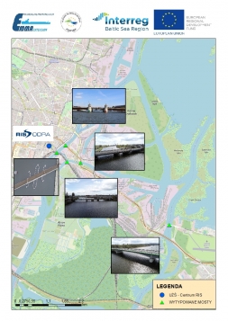
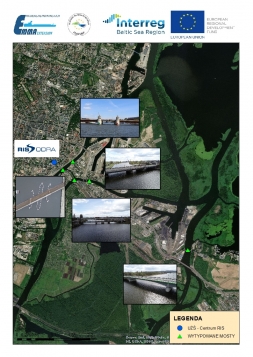
Picture: The map indicates the bridges of the Water Node of Szczecin, which will be analyzed in terms of the possibility of carrying out the task, i.e. hanging tables with clearance under the bridge. Eventually, two bridges will be selected for implementation.
River Information Services (RIS) stand for the harmonised information services which support traffic and transport management in inland navigation including interfaces with other modes of transport. The main purpose of the RIS system is to make inland navigation a transparent, reliable, flexible and easily accessible mode of transport that will be able to compete with other types of cargo transport. RIS system supports inland navigation by increasing the competitiveness of inland navigation, optimizing the use of infrastructure as well as improving security and environmental protection, this way contributing to a safe and efficient transport process and utilization of inland waterways to their fullest extent.
RIS-ODER achieves these goals through several activities. They consist of location of sensors in the RIS area (including CCTV cameras, AIS stations, hydro-meteorological stations) serving as the primary source of information; operation of the RIS Center, where information is processed; free provision of electronic navigation charts for inland navigation (IENC); issuing messages for captains (NtS); as well as vessel tracking and tracing (VTT). Participation in projects enables the improvement of navigation safety in the area covered by the RIS system. The implementation of automatic readings of safe clearances under bridges across Odra River as the Polish EMMA Extension pilot is therefore a great example of this type of activity in the area.
”The pilot fits perfectly into the activities of Inland Navigation Office in Szczecin for the benefit of its customers. Even though the investments will be implemented in the Szczecin area, it will have an influence on the route planning for cross-border shipments and operations between Polish and German inland waterway systems”, Jacek Wójcik says.

Press contact:
Mr. Jacek Wójcik
Project coordinator at Inland Navigation Office in Szczecin
jwojcik@szczecin.uzs.gov.pl