In the German pilot, EMMA partners focus on improving transport management with the development of an IT prototype that provides information relevant to the planning and operation of IWT. This is done using available data sources such as RIS (River Information Services) and combining it with necessary information for planning into one map-based web application.
The public section of the web application provides a real-time overview of the status of inland waterways in the region. It includes the status of infrastructure as well as general traffic information, thus informing for instance about water levels, obstructions, traffic density, and lock waiting times. The private section of the prototype is an add-on to the publicly available functions. It provides tailor-made services for vessel owners with limited data visibility for authorized users e.g. route- and fleet planning services.
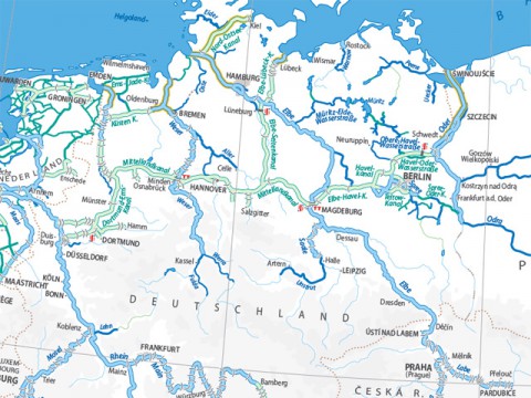
The web application provides benefits especially for shippers, transport organisers, vessel owners, and skippers. The digital map focuses geographically on the northern German waterways, including the Midland Canal, the Elbe Lateral Canal, the Elbe River, the Weser River, and the Berlin area up to the Odra River. Once the system is tested it should be transferred to other waterways in the BSR and beyond.
Interview with country coordinator
Contact: Arne Gehlhaar, gehlhaar@isl.org
ISL - Institute of Shipping Economics and Logistics
How would you describe your national pilot?
In the German pilot, we focus on improving transport management with the development of a software prototype that provides information relevant to the planning and operation of IWT. We do this by using available data sources such as RIS (River Information Services) and combining them with necessary information for planning into one map-based web application.
What are its expected results?
The German pilot will offer two sets of functionality - one public, the other one private with restricted access.
The public section of the web application will provide a real-time overview of the status of inland waterways in the region including the status of infrastructure as well as general traffic information.
The private section is an add-on to the publicly available functions. It will provide tailor-made services for vessel owners with limited data visibility for authorized users e.g. route- and fleet planning services.
How is the pilot proceeding?
The development process has already progressed significantly in the first months of the project's lifetime. The basic framework of the software prototype is available and the rudimentary functions of the public section are implemented. We have successfully integrated many sources of information such as the European RIS Reference Data (RIS Index), water levels and Notices to Skippers (NtS).
The digital map currently focuses geographically on the northern German waterways, including the Midland Canal, the Elbe Lateral Canal, the Elbe River, the Weser River, and the Berlin area up to the Odra River. Once the system is tested it should be transferred to other waterways in the BSR and beyond.
What kind of value do the project and the pilot bring to the region?
The web application provides benefits especially for shippers, transport organisers, vessel owners, and skippers. The pilot will greatly enhance the transparency and thus the predictability of inland waterway transport. This will make IWT more reliable and ultimately help to increase its competitiveness.
What are your thoughts and experiences of the EMMA project?
Even though EMMA follows one central goal, the approaches in each of the regions are very different, making EMMA a uniquely rich and diverse project. EMMA benefits especially from the productive spirit within the consortium and the dedication of the people involved. I am glad to be a part of this team!